I’m puzzled by the naming convention. We don’t call Woodall “Sheffield” or Michaelwood “Dursley”.
Also can the pins be shifted to 52.644063,-2.058389 and 52.644074,-2.054209 which is about the middle of each of the rows.
I’m puzzled by the naming convention. We don’t call Woodall “Sheffield” or Michaelwood “Dursley”.
Also can the pins be shifted to 52.644063,-2.058389 and 52.644074,-2.054209 which is about the middle of each of the rows.
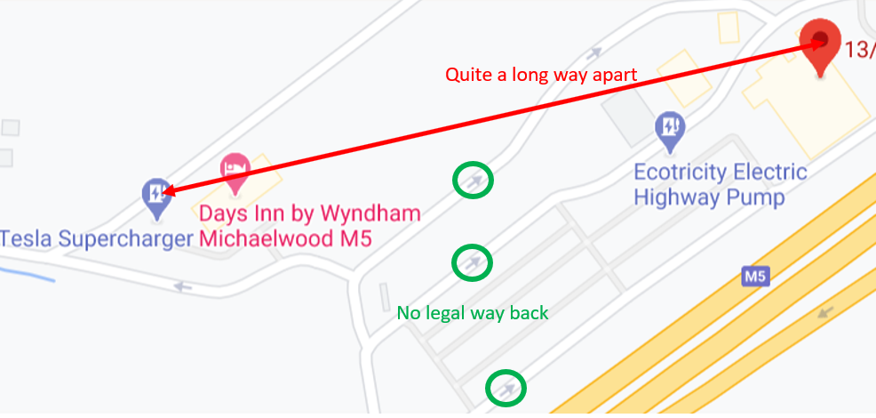
Agreed re: pin locations. The photos posted on the teslamotorsclub.com thread from @ TeslaInTheUK allow the location of both sites to be accurately identified.
Personally I’d wait to see what Tesla label these Superchargers (on the in-car Nav map) when they open before changing the labels on supercharge.info but you’re probably right that they’ll end up being named after the service area, i.e. Hilton Park Northbound/Southbound.
I changed the gps coordinates to the more precise locations.
I’ll leave the naming to someone with more knowledge what is common for sites in the UK.
The location data seems to be stored twice.
The revised positions I posted above are now used by the Map option (  ) but the old locations are still used in the Data tab and the gmap links in the Changes tab.
Seems a little crazy to have two sets of location data 
Hi Roberto
Thanks for moving the Wolverhapton pins. Did you see my comment about the duplicate location details (in the same thread)?
I’ve also noticed that the Dart’s Farm (Exeter) pin is where the two stalls were and doesn’t represent the new location. Google Maps has the right position, could you move this one too please.
Incidentally, it’s worth a look at the field just North of this location in the satellite view.
Cheers
I don’t think I see different pin locations, for me supercharge.info is consistently reporting (52.644063,-2.058389) and (52.644074,-2.054209) both if I navigate from the Changes tab (and read off the coordinates on the map pin pop-up boxes) and if I look at the values in the Data tab (I used a filter for Europe & UK and Wolverhampton then appears on page 2 if showing 50 per page). Possibly a page refresh issue?
The ‘tool tip’ is showing
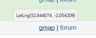
But the link is to
Looking at a few others, it seems that it is standard practice to have the gmap link to be the venue in general rather than the much more useful Lat/Long. Seems a bit odd that the gmap link isn’t generated from the coordinates, surely that’d be more sensible?
Tha Darts Farm one is particularly unhelpful being on the wrong side of the road but at least you can see the actual location as part of Google’s offering.
I expect there is some rationale behind the way the gmap links are generated. Maybe the idea is that because the search uses and address and postcode, Google Maps comes up with some context about the locality rather than precisely pinpointing the supercharger stalls. After all, the pin on the supercharge.info map should show you exactly where the stalls are (I’ve found most of the UK ones are pretty accurate, & the volunteers who maintain supercharge.info are good about updating any that have moved or are a bit off).